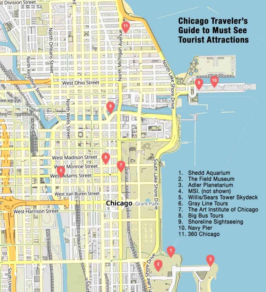
city of chicago maps
Hotel Maps • Mag. Mile Dining
• Attraction Maps • Lakefront Beaches
• O'Hare Airport Map

• Downtown Street Map

• Suburban Shopping Malls • City Venues Map
• Mag. Mile Shopping Map • Suburban Venues Map
• Top 30 Attractions • Neighborhood Maps
• Casinos Map • Museums Map
• State Street Stores Map  


Chicago Maps

Chicago Traveler’s maps will help you locate key attractions, theaters, hotels, venues and shopping destinations, both within Chicago and in its suburbs, and will help you find your way around O’Hare Airport.

When choosing your hotel, you can decide whether you want to stay downtown, on Michigan Avenue, near Navy Pier or the McCormick Place convention center, close to O’Hare Airport or in one of Chicago’s primary commercial suburbs, such as Schaumburg, Oakbrook or Naperville. Check out our hotel maps to pick the hotel that’s in the best location for you.

Our attractions map will help you plan your daily itinerary so that you can see as many of Chicago's attractions as possible.

Our venues maps will pinpoint the location of that concert, theater performance or sporting event you are planning to attend.

CHICAGO MAP RESOURCES

Find a variety of Chicago maps which present different areas and map types of Chicagoland. Included are street maps, city, suburban, expressway, hotel, theater, landmark, CTA, Metra, Pace, and other Chicago maps.   

Choose any of the Chicago map links on this page to display a ready reference for your travels in, and around Chicagoland. Each map source link will display in a new window. Your link to our site will be maintained when you close the map link window.

• Interactive Chicago Map
Locate attractions and zoom for detail on this Chicago Convention Bureau interactive map of downtown and inner-city Chicago. It may be a little confusing at first, but it could be worth the time to learn how to use it.

• Zoom Chicago Downtown/Loop Map
Although a little out of date, this zoomable map of Chicago's downtown can provide a great detail look, block by block.

• Lincoln Park Map
Zoomable PDF map of the Lincoln Park neighborhood from the Lincoln Park Chamber of Commerce. The map covers the entire Lincoln Park neighborhood from Diversey to North, and Lake Michigan to Ashland.

• Yahoo Maps!
High quality interactive map for Chicago locations and directions from Yahoo Maps.

• MapQuest
The other standard when it comes to general maps offered online.

• Chicago Landmark Maps
The links on this map feature photos, addresses, historical information and trivia about downtown's famous attractions and landmarks.

• Chicago Downtown Map
Simple map of downtown Chicago.

• Chicago Official Visitors Guide
Looking for a hard copy map? This guide has detailed maps of downtown Chicago and the metropolitan region. Order now!

• Chicago Suburban Map
Simple map of the Chicago suburbs.

• Area CTA Map
An extensive web site and map system for the entire Chicago Transit Authority System. This includes downtown, city, and suburban areas.

• Chicago Area Expressway Congestion Map from IDOT
The Chicago expressway system is complex and this map lays out the basic route system that gets you to where you are going if it is any significant distance.

• Download & Print the Metra Map for Chicago Area
Chicago area train route map from Metra showing all routes and stations throughout the entire Chicagoland system.

• Pace Regional Bus System Maps
You can access the complete surface bus system maps via this link. Go to the map section and search for the origin and/or destination points of interest.

• Zoomable Chicago Parking Map provided by PILMC.
Offers detailed info on downtown, Midway and O'Hare parking facilities.


1 Price-25 Attractions
SALE!
Buy Now


Featured: Chicago Video Collection
Top Chicago Attractions | Downtown Hotels Map | Suburban Hotels Map | Hot Things-To-Do
VISITOR GUIDES:
Navy Pier | Museum of Science | Theatre  | Shedd Aquarium | Chicago Tours